De CriaçãoWiki, a enciclopédia da ciência da criação.
Saltar para a navegaçãoSaltar para a pesquisa
Sem resolução maior disponível.
Summary
Glacial Lake Missoula was formed when a finger of the Cordilleran ice sheet crept southward into the Idaho panhandle, forming a large ice dam that blocked the mouth of the Clark Fork River, creating a massive lake 2,000 feet deep and containing more than 500 cubic miles of water. Glacial Lake Missoula stretched eastward for some 200 miles and contained more water than Lake Erie and Lake Ontario combined. When the highest of these ice dams failed, lake water burst through, shooting out at a rate 10 times the combined flow of all the rivers of the world. This towering mass of water and ice literally shook the ground as it thundered toward the Pacific Ocean, stripping away hundreds of feet of soil and cutting deep canyons -- "coulees" -- into the underlying bedrock. With flood speeds approaching 65 miles per hour, the lake would have drained in as little as 48 hours.
Copyright status:
This image is public domain because it was first published by the U.S. Geological Survey.
Source:
http://vulcan.wr.usgs.gov/LivingWith/Historical/LewisClark/Maps/map_missoula_floods.html
Histórico do ficheiro
Clique uma data e hora para ver o ficheiro tal como ele se encontrava nessa altura.
| Data e hora | Miniatura | Dimensões | Utilizador | Comentário |
|---|
| atual | 00h38min de 2 de abril de 2009 | 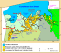 | 666 × 580 (26 kB) | Ashcraft | Glacial Lake Missoula was formed when a finger of the Cordilleran ice sheet crept southward into the Idaho panhandle, forming a large ice dam that blocked the mouth of the Clark Fork River, creating a massive lake 2,000 feet deep and containing more than |
Utilização local do ficheiro
A seguinte página usa este ficheiro: