Ficheiro:Mars HST Mollweide map 1999.png
Mars_HST_Mollweide_map_1999.png (800 × 400 píxeis, tamanho: 353 kB, tipo MIME: image/png)
Summary
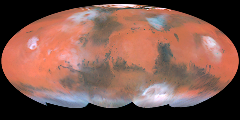
ABOUT THIS IMAGE: The four hemispheric views shown above have been combined into a full-color global map (called a Mollweide projection), showing the regions of Mars imaged by the Hubble telescope during the planet's closest approach to Earth. Latitudes below about 60 degrees south were not viewed by the telescope because the planet's north pole was tilted towards Earth during this time. This image is a composite of pictures taken with three filters: blues (410 nanometers), green (502 nanometers), and red (673 nanometers). The Hubble telescope's resolution is 12 miles per pixel (20 kilometers per pixel) near the Martian equator.
Object Name: Mars
Image Type: Astronomical
Photo Credit: Steve Lee (University of Colorado), Jim Bell (Cornell University), Mike Wolff (Space Science Institute), and NASA
Description
English: The four hemispheric views shown above have been combined into a full-color global map (called a Mollweide projection), showing the regions of Mars imaged by the Hubble telescope during the planet's closest approach to Earth.
Date
Composite of four images between April 27 and May 6, 1999.
Source
http://hubblesite.org/gallery/album/entire_collection/pr1999027f/ (Original Tif, resaved as PNG].)
Author
NASA.
Copyright status:
This file is in the public domain because it was solely created by NASA. NASA copyright policy states that "NASA material is not protected by copyright unless noted". (See NASA copyright policy page or JPL Image Use Policy.) |
|||
| Warnings: •Use of NASA logos, insignia and emblems are restricted per US law 14 CFR 1221. | |||
Source:
http://commons.wikimedia.org/wiki/File:Mars_HST_Mollweide_map_1999.png
Histórico do ficheiro
Clique uma data e hora para ver o ficheiro tal como ele se encontrava nessa altura.
| Data e hora | Miniatura | Dimensões | Utilizador | Comentário | |
|---|---|---|---|---|---|
| atual | 14h14min de 20 de abril de 2013 | | 800 × 400 (353 kB) | Luiz Alexandre Silva | ABOUT THIS IMAGE: The four hemispheric views shown above have been combined into a full-color global map (called a Mollweide projection), showing the regions of Mars imaged by the Hubble telescope during the planet's closest approach to Earth. Latitudes |
Utilização local do ficheiro
A seguinte página usa este ficheiro: