
|
This image was uploaded to the shared "Image Pool" and is usable on any CreationWiki site.
Please go to the Pool to edit its description.
|
Summary
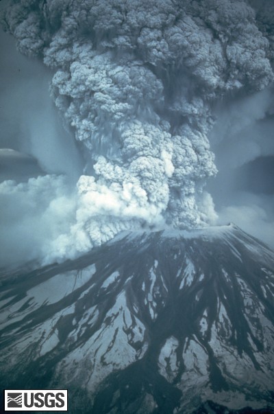
On May 18, 1980, at 8:32 a.m. Pacific Daylight Time, a magnitude 5.1 earthquake shook Mount St. Helens. The bulge and surrounding area slid away in a gigantic rockslide and debris avalanche, releasing pressure, and triggering a major pumice and ash eruption of the volcano. Thirteen-hundred feet (400 meters) of the peak collapsed or blew outwards. As a result, 24 square miles (62 square kilometers) of valley was filled by a debris avalanche, 250 square miles (650 square kilometers) of recreation, timber, and private lands were damaged by a lateral blast, and an estimated 200 million cubic yards (150 million cubic meters) of material was deposited directly by lahars (volcanic mudflows) into the river channels. Fifty-seven people were killed or are still missing.
USGS Photograph taken on May 18, 1980, by Austin Post.
Larger version available.
http://vulcan.wr.usgs.gov/Imgs/Jpg/MSH/Images/MSH80_eruption_mount_st_helens_05-18-80.jpg
Copyright status:
This image is public domain because it was first published by the U.S. Geological Survey
Source:
http://vulcan.wr.usgs.gov/Volcanoes/MSH/Publications/MSHPPF/MSH_past_present_future.html
File history
Click on a date/time to view the file as it appeared at that time.
| Date/Time | Thumbnail | Dimensions | User | Comment |
|---|
| current | 21:20, 17 April 2009 |  | 400 × 603 (57 KB) | Ashcraft | |
File usage
The following page uses this file:
This file contains additional information, probably added from the digital camera or scanner used to create or digitize it.
If the file has been modified from its original state, some details may not fully reflect the modified file.