File:Arabian tectonic plate overview map.gif
From CreationWiki, the encyclopedia of creation science
Jump to navigationJump to search
No higher resolution available.
Arabian_tectonic_plate_overview_map.gif (213 × 203 pixels, file size: 14 KB, MIME type: image/gif)
|
This image was uploaded to the shared "Image Pool" and is usable on any CreationWiki site. |
File history
Click on a date/time to view the file as it appeared at that time.
| Date/Time | Thumbnail | Dimensions | User | Comment | |
|---|---|---|---|---|---|
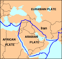
| current | 10:02, 3 January 2013 | | 213 × 203 (14 KB) | Drnhawkins | Overview map of the Arabian tectonic plate. http://neic.usgs.gov/neis/gifs/iran_plates.gif Used in document: http://neic.usgs.gov/neis/eq_depot/2004/eq_040528/neic_jaan_ts.html Tectonic Summary Magnitude 6.3 NORTHERN IRAN 2004 May 28 12:38:46 UTC U.S. G |
File usage
The following page uses this file: